 GeoData.NZ
OCEAN SALINITY
Type of resources
Available actions
Topics
Keywords
Contact for the resource
Provided by
Years
status
-
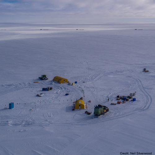
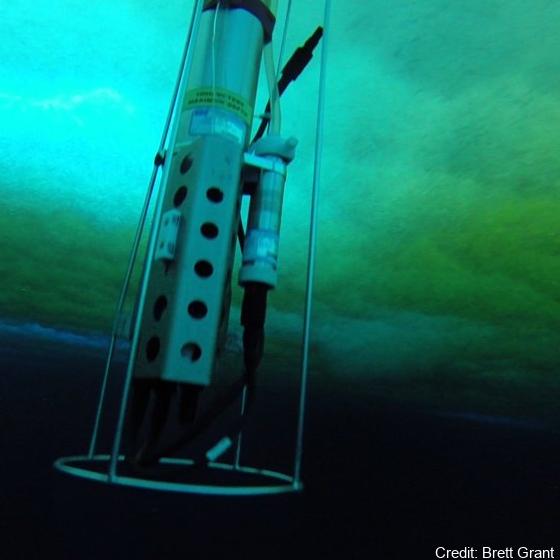
Here we provide data from the Ross Ice Shelf ocean cavity. The HWD2 Camp was established in October of 2017 at (-80 39.497, 174 27.678) where the ice is moving seaward at around ~600 m a-1 and is sourced from the Transantarctic Mountains. Profiling Instruments - Profiling was primarily conducted with an RBR Concerto CTD (conductivity-temperature depth) profiling instrument, and this was cross-calibrated against irregular profiles with an RBR Duet (pressure and temperature only), a SBE37 MicroCat CTD as well as moored SBE37 MicroCat CTDs. The RBR unit is small and has suitable sensor capability (temperature and conductivity accuracies of ±0.002°C and ±0.003 mS cm-1). Its conductivity cell design is not prone to fouling by ice crystals, making it ideal for work in the sometimes crystal-laden borehole conditions. We were inconsistent in how we mounted the CTD on its protective frame and this appeared to make small difference in the conductivity signal (resulting in an ~0.03 psu variation). This was post-corrected based on the essentially invariant mooring data from the lower water column as well as SBE37 cross-calibration profile data. Because of the potential for sediment contamination of the sensors, the profiles were mostly conservative in their proximity to the sea floor. On several occasions, profiles were conducted all the way to the sea floor. The temperature and salinity are presented in EOS-80 in order to compare with available data. Eighty-three profiles are provided here (ctd_HWD2_*.dat). In addition, limited microstructure profiling was conducted to provide insight into some of the mixing details. The profiles were conducted by lowering the instrument to the ice base then commencing a sequence of three up-down “yo-yos” before returning to the surface and downloading. A data segment is included here (VMP_HWD2.dat). There were some challenges registering the vertical coordinate for the profiles. The melting of the borehole generates a trapped pool of relatively fresh water. The interface between this and the ocean should be near the base of the hole or a little higher – with seawater intrusion. However, there were some instances where the interface was at a higher pressure (i.e. apparently in the open water column). The best explanation for this is that the water in the borehole is not at static equilibrium for some period after initial melting. We use 34.3 psu as a cut-off, in addition to a pressure criterion to identify the top of the useful oceanic profile. It is also not inconceivable that water was being ejected from the hole, but it is unlikely that this would have impacted in the consistent observed pattern. Instrumented Mooring - The mooring instruments at HWD2-A comprised 5 Nortek Aquadopp single point current meters in titanium housings reporting to the surface (30-minute interval, Table SI-Three) via an inductive modem to a Sound-9 data logger and Iridium transmitter. The current meter measurements were corrected to account for the 138° magnetic declination offset (i.e. the south magnetic pole is to the north-west of the field site). Five files are provided here (HWD2_Init_rcm*.dat4). Stevens Craig, Hulbe Christina, Brewer Mike, Stewart Craig, Robinson Natalie, Ohneiser Christian, Jendersie Stefan (2020). Ocean mixing and heat transport processes observed under the Ross Ice Shelf control its basal melting. Proceedings of the National Academy of Sciences, 117 (29), 16799-16804. https://doi.org/10.1073/pnas.1910760117
-
Temperature and salinity observations were made at nominal depths of 75 m and 100 m, respectively, by Sea Bird Electronics sensors. Acoustic volume backscatter measurements were made by an ASL Environmental Sciences Acoustic Zooplankton Fish Profiler (AZFP) operating at four-frequencies (125 kHz, 200 kHz, 455 kHz and 769 kHz). The AZFP profiled the top 25 m of the water column in 0.1 m bins. All instruments were deployed through a landfast sea ice cover that was approximately 2 m thick. The WWW Tide and Current Predictor model was used to generate tidal height forecasts for the deployment periods. GET DATA: https://doi.pangaea.de/10.1594/PANGAEA.923620
-
Here we present physico-chemical data collected during two research cruises conducted to and across the Ross Sea, Antarctica in the summer of 2018 (February-March) and 2019 (January-February). The dataset includes measurements of temperature, salinity, oxygen, par and transmissivity obtained with a Sea-Bird Electronics (SBE) 911plus CTD. The CTD sensor was configured with SBE 3plus, SBE 4, and SBE 43 dual sensors for the parameters above, in addition to a seapoint fluorescence sensor, and a photosynthetically active radiation (PAR) sensor (Biospherical Instruments QCP‐2300L‐HP). These data were used to provide oceanographic context to DNA metabarcoding analysis of 18S rRNA V4 region that was carried out on DNA samples collected in parallel to nutrient and chlorophyll-a samples. Fastq samples from DNA metabarcoding analysis and the associated metadata (including nutrients, Chlorophyll-a, and size-fractionated chlorophyll-a) were deposited to GenBank under project numbers PRJNA756172 (2018 cruise) and PRJNA974160 (2019 cruise). The study resulting from this analysis has been submitted to Limnology and Oceanography. RELATED PUBLICATION: Cristi, A., Law, C.S., Pinkerton, M., Lopes dos Santos, A., Safi, K. and Gutiérrez-Rodríguez, A. (2024). Environmental driving forces and phytoplankton diversity across the Ross Sea region during a summer–autumn transition. Limnol Oceanogr. https://doi.org/10.1002/lno.12526
-
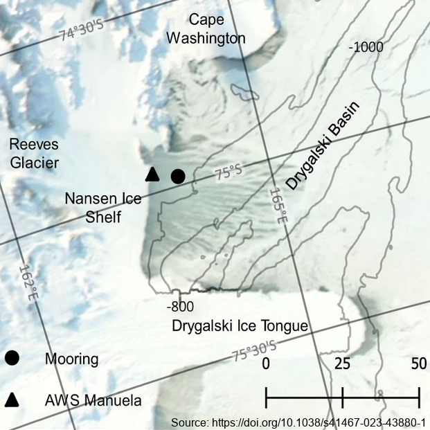
The mooring was deployed from February 2017 through February 2018 at 74.97° S, 163.96° E, approximately 7km east of the Nansen Ice Shelf in a region of TNB. The purpose of this study was to utilize data from a uniquely positioned and densely instrumented mooring to calculate HSSW production rates in TNB from continuous, in-situ observations. Moored instrumentation consisted of 7 SeaBird Electronics conductivity and temperature (SBE37-SM/SMP MicroCAT) sensors at depths of 47, 95, 119, 144, 168, 219, and 360 m and an upward-facing 600 kHz Nortek Acoustic Wave and Current (AWAC) profiler at 37 m depth, collecting both current velocity profiles in the upper ~35 m of the water column as well as Acoustic Surface Tracking (AST) measurements. Temperature and salinity measurements were validated against a shipboard conductivity-temperature-depth (CTD) cast performed upon deployment of the mooring. Temperature and salinity at 47 m and 95 m were additionally validated against a CTD cast performed upon recovery of the mooring. Full details of methods can be found in https://doi.org/10.1038/s41467-023-43880-1 GET DATA: ukm2103@columbia.edu
-
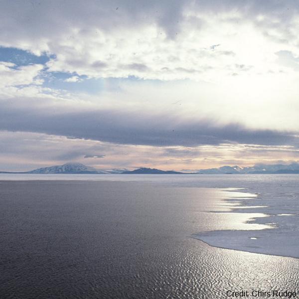
Data from a measurement campaign examining the oceanic connection between an ice shelf cavity and sea ice. Here we present data from the ocean boundary-layer in an Ice Shelf Water outflow region from the Ross/McMurdo Ice Shelves. From a fast ice field camp during the Spring of 2015, we captured the kinematics of free-floating relatively large (in some cases 10s of mm in scale) ice crystals that were advecting and then settling upwards in a depositional layer on the sea ice underside (SIPL, sub-ice platelet layer). Simultaneously, we measured the background oceanic temperature, salinity, currents and turbulence structure. At the camp location the total water depth was 536 m, with the uppermost 50 m of the water column being in-situ super-cooled. Tidal flow speeds had an amplitude of around 0.1 m s-1 with dissipation rates in the under-ice boundary layer measured to be up to e=10-6 W kg-1. Acoustic sampling (200 kHz) identified backscatter from large, individually identifiable suspended crystals associated with crystal sizes larger than normally described as frazil. Crystal sizes in the SIPL were also measured. RELATED PUBLICATION: https://doi.org/10.3389/fmars.2023.1103740 GET DATA: https://doi.org/10.17882/90432
-

In collaboration between the Korea Polar Research Institute and NIWA, an oceanographic mooring was deployed close to the bottom depth near the Drygalski Ice Tongue (lat:-75.275700, lon:164.067300) on 9 March 2018 as a part of the ANA08C research cruise, and it was recovered on 3 January 2019 To monitor physical properties(Temperature, Salinity, Current) of deep water near the Drygalski Ice Tongue. To monitor physical properties (Temperature, Salinity, Current) of deep water near the Drygalski Ice Tongue. GET DATA: https://kpdc.kopri.re.kr/search/9826749c-376a-4751-8812-702cec76c4c0
-

In collaboration between Korea Polar Research Institute and NIWA, an oceanographic mooring was deployed to the North of the Drygalski Ice Tongue (lat:-75.360083, lon:164.748633) on 12 December 2014 as a part of the ANA05A research cruise, and it was recovered on 10 December 2015. To monitor physical properties (Temperature, Salinity, Current) of ocean water in the north of the Drygalski Ice Tongue. GET DATA: https://kpdc.kopri.re.kr/search/1a10def2-13e7-4829-b46d-07bebb748ce2
-

In collaboration between Korea Polar Research Institute and NIWA, an oceanographic mooring was deployed close to the bottom depth near the Drygalski Ice Tongue (lat:-75.275700, lon:164.067300) on 9 March 2018 as a part of the ANA08C research cruise, and it was recovered on 3 January 2019. To monitor physical properties (Temperature, Salinity, Current) of deep water near the Drygalski Ice Tongue. GET DATA: https://kpdc.kopri.re.kr/search/9826749c-376a-4751-8812-702cec76c4c0
-

In collaboration between Korea Polar Research Institute and NIWA, an oceanographic mooring was deployed to the North of the Drygalski Ice Tongue (-75.360083, lon:164.748633) on 3 March 2018 as a part of the ANA08C research cruise, and it was recovered on 4 January 2019. To monitor physical properties (Temperature, Salinity, Current) of ocean water in the north of the Drygalski Ice Tongue. GET DATA: https://kpdc.kopri.re.kr/search/90416713-7e1f-4c4d-a0b6-46c8deeea43e
-

In collaboration between Korea Polar Research Institute and NIWA, an oceanographic mooring was deployed to the south of the Drygalski Ice Tongue (lat:-75.488417, lon:163.174350) on 12 February 2017 as a part of the ANA07C research cruise, and it was recovered on 7 March 2018. To monitor physical properties (Temperature, Salinity, Current) of ocean water in the south of the Drygalski Ice Tongue. GET DATA: https://kpdc.kopri.re.kr/search/9245184f-b187-4c1e-ad6f-32ed1f9493c8